Cat-five Maila set to weaken before Queensland crossing
Ben McKay |
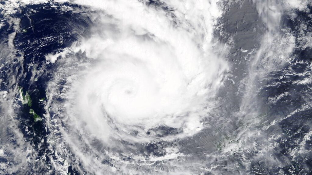
Tropical Cyclone Maila has surged to become one of the strongest storms so close to the equator on record, intensifying in the warm waters of the Solomon Sea.
On Wednesday morning, Maila was upgraded to a category five system, with maximum sustained winds of around 215km/h, and stronger gusts.
Maila is expected to make landfall in far north Queensland, possibly on Monday, but will do so as a weakened storm.
Unusually, the eye has lingered at sea between Solomon Islands and Papua New Guinea for several days, keeping the most devastating winds away from major populations.
Its effects are still being felt in the two nations, including Bougainville, with broadcaster SIBC reporting three members of one family are missing after a boat capsized in heavy seas.
Images posted to social media show destruction of property in remote parts of the Solomon Islands’ Western and Choiseul provinces.
The Bureau of Meteorology registered Maila’s deepest central pressure at 932 hPa on Wednesday morning, just behind Narelle’s 931 hPa on March 19.
Maila will also follow Narelle’s path across Queensland and make landfall in a similar vicinity, but forecasters believe it will do so with a weaker intensity.
BOM senior meteorologist Liam Smart told AAP Maila was a record-setter for the region.
“It’s the strongest cyclone this far north in the Solomon Sea on record,” he told AAP.
While it is technically possible for cyclones – known in the northern hemisphere as hurricanes or typhoons – to form at just one degree north or south of the equator, it is exceedingly rare.
In 1970, Typhoon Kate registered a similar strength at about 7.5 degrees north of the equator.
On Wednesday, Maila sat about 9.0 degrees south, heading slowly north before a predicted pivot to the west.
WeatherWatch head forecaster Philip Duncan said other systems had button-holed Maila into the Solomon Sea.
“The location, in a little bubble of sea, is just ideal for what’s happening,” he told AAP.
“It’s stalled, stuck in the same area and getting all that energy off the Solomon Sea, such a warm body of water.”
Most modeling suggests Maila will head across Papua New Guinea towards far north Queensland.
A journey over the mountainous tip of the Papuan Peninsula would see it weaken to possibly even a tropical low on arrival.
“There’s a big question mark for Queensland as to what will happen,” Mr Duncan said.
Mr Smart said the system was already weakening from peak intensity, and its severity on landfall in Australia would depend on its route.
“There’s disagreement between models as to how strong it will be … we’re expecting around a category two, possibly a three,” he said.
A second cyclone in the Pacific region, tropical cyclone Vaianu, moved south of Fiji on Wednesday as a category three system with sustained winds up to 130km/h.
The cyclone caused storms and flooding in Fiji, particularly on the western and southern coast of Viti Levu.
A Fiji Airways flight from Sydney on Tuesday abandoned attempts to land in Nadi after three approaches, diverting to Tonga.
Most tracking models has Vaianu crashing into New Zealand’s North Island on the weekend, with the MetService warning of “damaging, potentially life-threatening winds, heavy rain, and hazardous coastal conditions”.
A strong wind watch has been issued for the entire North Island on Sunday, with forecasters tipping it will be upgraded in parts to an orange or red warning, the highest level of alert.
Mr Duncan said the Coromandel Peninsula, Tairawhiti region and Northland were likely to see the highest rainfalls.
AAP