Snow and a heatwave as four seasons greet Christmas Day
Abe Maddison |
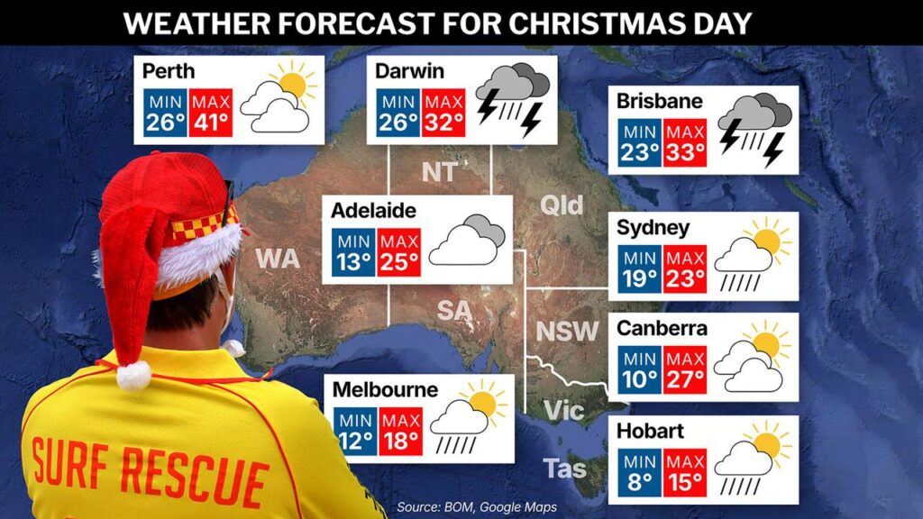
Snow, hail and thunderstorms, a heatwave, a cyclone and the risk of flooding – Australians can expect the full spectrum of weather events for Christmas.
Canberra (partly cloudy, 28C) and Adelaide (cloud clearing, 25C) will be the ideal capitals for an outdoor Christmas lunch, with wildly varying extremes forecast in other major cities.
Bureau of Meteorology senior meteorologist Jonathan How said Perth (partly cloudy, 40) was “in the middle of a heatwave” on Wednesday, with dry winds and an extreme fire danger forecast on Christmas Day and the possibility of dry thunderstorms northeast of the city.

“We could see some new fires tomorrow with that dry lightning … but it’s hard to say exactly where that will be,” he said.
“The good news is that we are seeing cooler conditions extend across the coast later on Christmas evening, and then we’ll see a much cooler Boxing Day, dropping back into the 20s, and a few showers.”
A record total of 38 aircraft will be available to respond to any bushfire threats in WA after the Department of Fire and Emergency Services brought in two extra Black Hawk helicopters.
Brisbane (shower or two, possible storm, 33C) is facing a hot, dry start to festivities.
“But then we will see afternoon showers and thunderstorms, and we could see severe thunderstorms across Brisbane through the afternoon and evening,” Mr How said.
Sydney, (shower or two, 23) will have a cooler, cloudy day with a few showers in the morning and afternoon, “but the showers will break up and dry out after lunch”, Mr How said.
Canberra “is probably the pick of the capitals” with a warm day and “Adelaide is also looking pretty nice”, he said.
Melbourne (17C) is forecast to have its coldest Christmas Day since 2006, with showers possible in the morning and afternoon.
Hobart (showers, 15C) will also be well-suited to indoor celebrations, with cold conditions, “snow on the mountain, local hail and a bit of a wind chill”, Mr How said.
Darwin (rain, storm, 30C) can expect a tropical downpour of up to 50mm.
“It’s a little bit earlier than what we typically expect, but monsoon is now officially under way across the north of the country, and what that means is that we are seeing very widespread rain and thunderstorms,” Mr How said.

There is a flood watch for outback WA, Queensland and the NT and “it’s a very big flood watch – the area is about the size of NSW”, Mr How said.
“Over the next couple of days, we’ll have a better idea of which of those areas might need to be upgraded to a warning.”
The Cocos Islands, 2750km northwest of Perth, are bracing for Tropical Cyclone Grant, which is expected to move north of the islands on Christmas Day and could be upgraded to a category two system overnight.
“They’re expecting to see damaging winds increasing and heavy rainfall, but thankfully, it’s easing up on Boxing Day,” Mr How said.
AAP